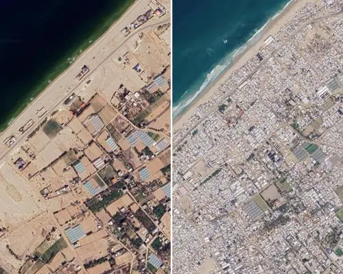
Satellite Evidence Reveals Ongoing Urban Devastation
New satellite images added to Google Maps reveal the scale of destruction in Gaza, captured in June 2024, as the territory's 2.3 million residents continue to face a deepening humanitarian crisis following three years of conflict.
The updated imagery shows extensive damage to residential buildings, commercial facilities, religious sites, and critical infrastructure across the besieged territory. The destruction has accelerated since a fragile ceasefire was announced, with entire neighborhoods reduced to rubble and essential services severely disrupted.
The high-resolution images provide a stark overview of the deteriorating conditions on the ground. Entire city blocks appear flattened, with debris fields stretching across what were once densely populated areas. Infrastructure such as roads, water systems, and electricity networks show signs of repeated damage and incomplete repairs.
How Is the Humanitarian Situation Evolving?
Local residents have reported that the imagery confirms what they witness daily: the slow erosion of their communities through continued conflict and inadequate access to basic necessities. Aid organizations have repeatedly warned that the lack of reconstruction materials and restricted movement of goods and people continues to hinder recovery efforts.
The United Nations and multiple aid agencies have expressed concern over the worsening conditions in Gaza, where access to clean water, food, and medical care remains critically limited. The population has endured cycles of violence and displacement, with many families living in temporary shelters or makeshift accommodations.
International observers note that while some areas show tentative signs of rebuilding, the overall trajectory remains downward. The combination of ongoing insecurity, economic collapse, and restricted aid delivery has left millions dependent on humanitarian assistance that is often insufficient or delayed.
The situation remains fluid, with periodic escalations disrupting any progress toward stabilization. Analysts caution that without a sustained ceasefire and a coordinated international response, the humanitarian toll is likely to increase.
Frequently Asked Questions
What do the new Google Maps images show? The June 2024 satellite images reveal extensive destruction of homes, businesses, religious sites, and infrastructure across Gaza, highlighting the ongoing humanitarian crisis affecting 2.3 million people.
When were the images captured? The images were taken in June 2024, providing a recent snapshot of the damage accumulated over three years of conflict and a fragile ceasefire period.
What is the current humanitarian situation in Gaza? The population continues to face severe shortages of water, food, and medical care, with aid delivery hampered by ongoing insecurity and restricted access to the territory.